Valuing irrigable land
When severe floods hit almost one million people in Malawi 11 months ago, Martha Moyo lost her flourishing rice crop to murky floodwater from adjacent slopes in Traditional Authority Nkhulambe, Phalombe.
“The flooding evoked memories of Napolo, the 1991 avalanche which shattered homes on the foot of Michesi Hill, washing away crops, livestock and other vital assets as rivers inundated with rocks rolling down the mountain left villages mourning. This time, it buried my rice in sand and silt, leaving me with no single grain for my family of six children,” she says.
Moyo, 39, is a lead farmer selected to popularise high-yielding agricultural techniques in her rural setting as rains become unpredictable due to climate change.
Gazing at the highlands where some farmers seldom yield enough maize to take them to the next harvesting season, she sees too few trees to stop water scraping topsoil on the way to the low-lying rice plots.
“In fact,” she says “the fields are dotted with mango trees here and there. We have cut down indigenous trees that once slowed rainwater to enter the soil so that we can yield more,” she says.
Moyo has joined a group which plants trees on river banks and on farms to conserve soil and water as government wants to construct an irrigation scheme in the floodplain dotted with rice plots.
“The scheme won’t yield anything without water and fertile soils. If we bring back the green cover, what happened to my rice will never occur again,” she says.
The group has constructed bunds and planted vetivar grass across steep slopes to stop water from opening gullies on farmlands.
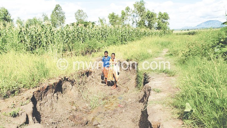
The United Nations’ Food and Agriculture Organisation (FAO) estimates that farmers in Malawi lose 29 tonnes of topsoil every year. Shockingly, it can take over a century to restore topsoil the thickness of a brick.
The State-run Programme for Rural Irrigation Development (Pride) and Enhancing Resilience of Agro-ecology Systems Project (Erasp) is promoting soil and water conservation in seven districts where 15 irrigation schemes will take shape. Phalombe, Zomba, Machinga, Chitipa and Nkhata Bay will get two schemes each while Karonga will have three and Rumphi one.
Says Mundy Makoko, project coordinator: “The project recognises that without addressing environmental degradation, the investment in irrigation which the government is undertaking will face several risks related to climate change, including erratic rains, drought, flooding and inadequate water for irrigation.
“This is why we are supporting communities in implementing catchment management activities to restore degraded areas where the scheme will be located.”
Skefa January’s group is part of a movement to plant indigenous trees along Nthita, Mude and Bwanje rivers in Phalombe.
“If we make our area green again, soil erosion and siltation of rivers will be history and our scheme will benefit us for many years. We’ll be growing crops twice or thrice a year to overcome hunger and poverty,” he says.
For January, the New Year’s Day was no holiday. His group took advantage of the rains to plant trees along a river in their midst. They have also constructed eight bunds across steep slopes to stop run-offs.
District forestry officer Moses Mtambo says: “Trees reduce water speed. We want the water to go into the soil for crops’ well-being, not to erode the soil. Yields are already falling due to barren fields and climate change.”
Roderick Mateauma, district commissioner for Phalombe, commends the landscape restoration exercise to make the schemes sustainable.
“Nkhulambe is the food basket of Phalombe and the cities of Zomba and Blantyre. We need to safeguard the multi-million kwacha irrigation infrastructure so that the target communities do not return to hunger and poverty when the project phases out,” he says.
The schemes, currently at designing stage, were identified through the National Irrigation Sector Master Plan, says Pride-Erasp regional environmental officer Benjamin Kamanga.
The blueprint shows Phalombe has about 15 000 hecaters irrigable land, but only irrigates 2 170 hectares.
“With the addition of 301 to 550 hectares if we ultilise water from Namanjalo River and groundwater in Nkhulambe, we will increase the irrigated land to almost 3 000ha.
“As for Wowo, it has been there since 1984, but it was destroyed by floods. We will construct a new one,” says district irrigation officer Trecio Kandinga.
For Moyo, valuing the potential irrigation sites is actually protecting them from degrading activities so that they can meet extensive needs of present and future generations without fail.
She states: “This will not be possible if we continue farming in mountains where yield is falling due to unpredictable and barrens soils. Some still farm too close to rivers where we are planting trees.
“We may not see the immediate benefits of what we are doing, but our children and their children will thank us if they inherit a greener planet, not the brown spots in steep slopes.”